Sunnyvale, California, Hgh State Clinic, Hgh Injections, Hrt Doctors
Sunnyvale, California Blood Testing Facilities
 Represents a LabCorp blood testing facility
 Represents a Quest Diagnostics blood testing facility
Nearby Labcorp Blood Testing facilities:
- Labcorp Center Distance: 0 m, 901 W. El Camino Real, Sunnyvale, Santa Clara County, CA, 94087
- Labcorp Center Distance: 2 m, 2500 Hospital Dr Bldg 11, Mountain View, Santa Clara County, CA, 94040
- Labcorp Center Distance: 5 m, 316 Rosewood Ave. 2Nd Floor, San Jose, Santa Clara County, CA, 95117
- Labcorp Center Distance: 6 m, 2100 Forest Ave Ste 111, San Jose, Santa Clara County, CA, 95128
- Labcorp Center Distance: 7 m, 50 E. Hamilton Ave. Suite 80, Campbell, Santa Clara County, CA, 95008
- Labcorp Center Distance: 8 m, 853 Middlefield Rd Ste 6, Palo Alto, Santa Clara County, CA, 94301
- Labcorp Center Distance: 9 m, 2505 Samaritan Dr Ste 105, San Jose, Santa Clara County, CA, 95124
- Labcorp Center Distance: 10 m, 266 N Jackson Ave Ste 4, San Jose, Santa Clara County, CA, 95116
- Labcorp Center Distance: 12 m, 2147 Mowry Ave Ste C1, Fremont, Alameda County, CA, 94538
- Labcorp Center Distance: 13 m, 2060 Aborn Rd Ste 200, San Jose, Santa Clara County, CA, 95121
- Labcorp Center Distance: 14 m, 393 Blossom Hill Rd Ste 350, San Jose, Santa Clara County, CA, 95123
- Labcorp Center Distance: 17 m, 27171 Calaroga Ave. Suite 6, Hayward, Alameda County, CA, 94545
- Labcorp Center Distance: 22 m, 4125 Mohr Ave. Suite Am, Pleasanton, Alameda County, CA, 94566
- Labcorp Center Distance: 23 m, 5860 Owens Dr. Suite 120, Pleasanton, Alameda County, CA, 94588
- Labcorp Center Distance: 24 m, 13847 E 14Th St Suite 100, San Leandro, Alameda County, CA, 94578
- Labcorp Center Distance: 26 m, 1505 Soquel Dr Ste 3, Santa Cruz, Santa Cruz County, CA, 95065
- Labcorp Center Distance: 27 m, 2305 Camino Ramon Ste 110, San Ramon, Contra Costa County, CA, 94583
- Labcorp Center Distance: 29 m, 4165 Blackhawk Plz Circle 165, Danville, Contra Costa County, CA, 94506
- Labcorp Center Distance: 32 m, 1505 St. Alphonsus Way, Alamo, Contra Costa County, CA, 94507
- Labcorp Center Distance: 33 m, 272 Green Valley Road, Freedom, Santa Cruz County, CA, 95019
- Labcorp Center Distance: 34 m, 2622 Ocean Ave., San Francisco, San Francisco County, CA, 94132
- Labcorp Center Distance: 35 m, 700 W. 6Th St. Ste E, Gilroy, Santa Clara County, CA, 95020
- Labcorp Center Distance: 36 m, 120 La Casa Via Ste 101, Walnut Creek, Contra Costa County, CA, 94598
- Labcorp Center Distance: 37 m, 1601 Ygnacio Valley Road, Walnut Creek, Contra Costa County, CA, 94598
- Labcorp Center Distance: 38 m, 500 Lennon Lane, Walnut Creek, Contra Costa County, CA, 94598
- Labcorp Center Distance: 39 m, 401 Gregory Lane Suite 136, Pleasant Hill, Contra Costa County, CA, 94523
- Labcorp Center Distance: 40 m, 5161 Clayton Road Ste H, Concord, Contra Costa County, CA, 94520
- Labcorp Center Distance: 41 m, 2700 Grant St. Suite 107, Concord, Contra Costa County, CA, 94520
- Labcorp Center Distance: 42 m, 2415 High School Ave. Ste 200, Concord, Contra Costa County, CA, 94520
- Labcorp Center Distance: 43 m, 2089 Vale Rd Ste 14, San Pablo, Contra Costa County, CA, 94806
- Labcorp Center Distance: 44 m, 2220 Gladstone Dr. Suite 7, Pittsburg, Contra Costa County, CA, 94565
- Labcorp Center Distance: 45 m, 2160 Appian Way Ste 205, Pinole, Contra Costa County, CA, 94564
- Labcorp Center Distance: 47 m, 1367 East Second Street, Benicia, Solano County, CA, 94510
- Labcorp Center Distance: 48 m, 150 Glen Cove Marina Rd. 105, Vallejo, Solano County, CA, 94591
- Labcorp Center Distance: 51 m, 1326 Natividad Rd. Suite A, Salinas, Monterey County, CA, 93906
- Labcorp Center Distance: 53 m, 559 E. Alisal St. Ste 104, Salinas, Monterey County, CA, 93905
- Labcorp Center Distance: 54 m, 1173 Fremont Blvd Ste B, Seaside, Monterey County, CA, 93955
- Labcorp Center Distance: 57 m, 1617 N. California Street, Stockton, San Joaquin County, CA, 95204
- Labcorp Center Distance: 60 m, 1541 Florida Ave. Suite 102, Modesto, Stanislaus County, CA, 95350
- Labcorp Center Distance: 66 m, 1801 Colorado Ave. Suite 200, Turlock, Stanislaus County, CA, 95382
- Labcorp Center Distance: 67 m, 3448 Villa Lane Suite 103, Napa, Napa County, CA, 94558
- Labcorp Center Distance: 68 m, 153 Lynch Creek Way, Petaluma, Sonoma County, CA, 94954
- Labcorp Center Distance: 75 m, 1370 Medical Center Dr Ste B, Rohnert Park, Sonoma County, CA, 94928
- Labcorp Center Distance: 81 m, 4769 Hoen Avenue, Santa Rosa, Sonoma County, CA, 95405
- Labcorp Center Distance: 82 m, 1111 Sonoma Ave Ste 121, Santa Rosa, Sonoma County, CA, 95405
- Labcorp Center Distance: 84 m, 3540 Mendocino Ave Ste 400, Santa Rosa, Sonoma County, CA, 95403
- Labcorp Center Distance: 86 m, 424 E. Yosemite Ave. Suite E, Merced, Merced County, CA, 95340
- Labcorp Center Distance: 88 m, 500 University Ave 2Nd Fl, Sacramento, Sacramento County, CA, 95825
- Labcorp Center Distance: 89 m, 2 Scripps Dr. Suite 303, Sacramento, Sacramento County, CA, 95825
- Labcorp Center Distance: 90 m, 8465 Old Redwood Hwy Ste 400, Windsor, Sonoma County, CA, 95492
- Labcorp Center Distance: 97 m, 6620 Coyle Ave Ste 109, Carmichael, Sacramento County, CA, 95608
Nearby Quest Blood Testing facilities:
- Quest Center Distance: 1 m, 877 W Fremont Avenue, Sunnyvale, Santa Clara County, CA, 94087-2332
- Quest Center Distance: 2 m, 205 South Dr, Mountain View, Santa Clara County, CA, 94040-4323
- Quest Center Distance: 6 m, 123 Disalvo Ave, San Jose, Santa Clara County, CA, 95128-1717
- Quest Center Distance: 8 m, 840 Willow St, San Jose, Santa Clara County, CA, 95125-2384
- Quest Center Distance: 9 m, 2581 Samaritan Drive, San Jose, Santa Clara County, CA, 95124-4112
- Quest Center Distance: 10 m, 2618 Alum Rock Ave, San Jose, Santa Clara County, CA, 95116-2621
- Quest Center Distance: 12 m, 2365 Quimby Rd, San Jose, Santa Clara County, CA, 95122-1337
- Quest Center Distance: 13 m, 556 Mowry Avenue, Fremont, Alameda County, CA, 94536-4186
- Quest Center Distance: 14 m, 1100 Laurel Street, San Carlos, San Mateo County, CA, 94070-5000
- Quest Center Distance: 18 m, 1241 East Hillsdale Blvd, Foster City, San Mateo County, CA, 94404-0000
- Quest Center Distance: 22 m, 5720 Stoneridge Mall Road, Pleasanton, Alameda County, CA, 94588-2851
- Quest Center Distance: 24 m, 120 S El Camino Real, Millbrae, San Mateo County, CA, 94030-3133
- Quest Center Distance: 25 m, 1090 E Stanley Blvd, Livermore, Alameda County, CA, 94550-4157
- Quest Center Distance: 26 m, 1595 Soquel Drive, Santa Cruz, Santa Cruz County, CA, 95065-1720
- Quest Center Distance: 28 m, 7200 Bancroft Ave, Oakland, Alameda County, CA, 94605-2468
- Quest Center Distance: 29 m, 2111 Whitehall Place, Alameda, Alameda County, CA, 94501-6160
- Quest Center Distance: 31 m, 901 Campus Dr, Daly City, San Mateo County, CA, 94015-4930
- Quest Center Distance: 33 m, 202 Green Valley Rd, Freedom, Santa Cruz County, CA, 95019-3135
- Quest Center Distance: 34 m, 9360 No Name Uno, Gilroy, Santa Clara County, CA, 95020-3535
- Quest Center Distance: 35 m, 7880 Wren Avenue, Gilroy, Santa Clara County, CA, 95020-7801
- Quest Center Distance: 36 m, 108 La Casa Via, Walnut Creek, Contra Costa County, CA, 94598-3013
- Quest Center Distance: 39 m, 401 Gregory Ln, Pleasant Hill, Contra Costa County, CA, 94523-2836
- Quest Center Distance: 41 m, 632 West 11Th Street, Tracy, San Joaquin County, CA, 95376-3856
- Quest Center Distance: 42 m, 1181 Central Boulevard, Brentwood, Contra Costa County, CA, 94513-2252
- Quest Center Distance: 46 m, 500 Alfred Nobel Drive, Hercules, Contra Costa County, CA, 94547-1839
- Quest Center Distance: 47 m, 1000 S Eliseo Dr, Greenbrae, Marin County, CA, 94904-2133
- Quest Center Distance: 49 m, 1045 Sperry Ave, Patterson, Stanislaus County, CA, 95363-9286
- Quest Center Distance: 51 m, 631 E Alvin Dr, Salinas, Monterey County, CA, 93906-3056
- Quest Center Distance: 53 m, 212 San Jose St, Salinas, Monterey County, CA, 93901-3928
- Quest Center Distance: 54 m, 757 Pacific St, Monterey, Monterey County, CA, 93940-2819
- Quest Center Distance: 56 m, 2291 W March Ln, Stockton, San Joaquin County, CA, 95207-6664
- Quest Center Distance: 57 m, 510 E. Magnolia Street, Stockton, San Joaquin County, CA, 95202-1850
- Quest Center Distance: 58 m, 2800 N California St, Stockton, San Joaquin County, CA, 95204-3759
- Quest Center Distance: 59 m, 1801 E March Ln, Stockton, San Joaquin County, CA, 95210-6660
- Quest Center Distance: 60 m, 1524 Mchenry Ave, Modesto, Stanislaus County, CA, 95350-4566
- Quest Center Distance: 61 m, 2531 E Whitmore Ave, Ceres, Stanislaus County, CA, 95307-2646
- Quest Center Distance: 65 m, 801 S Ham Ln, Lodi, San Joaquin County, CA, 95242-7502
- Quest Center Distance: 66 m, 777 E Hawkeye Ave, Turlock, Stanislaus County, CA, 95380-7507
- Quest Center Distance: 67 m, 770 Mason St, Vacaville, Solano County, CA, 95688-4648
- Quest Center Distance: 68 m, 1550 Professional Drive, Petaluma, Sonoma County, CA, 94954-6655
- Quest Center Distance: 81 m, 990 Sonoma Ave, Santa Rosa, Sonoma County, CA, 95404-4813
- Quest Center Distance: 82 m, 8191 Timberlake Way, Sacramento, Sacramento County, CA, 95823-5418
- Quest Center Distance: 85 m, 3377 G Street, Merced, Merced County, CA, 95340-0998
- Quest Center Distance: 90 m, 1837 E Gibson Rd, Woodland, Yolo County, CA, 95776-5168
- Quest Center Distance: 92 m, 2288 Auburn Boulevard, Sacramento, Sacramento County, CA, 95821-1619
- Quest Center Distance: 95 m, 7423 Fair Oaks Blvd, Carmichael, Sacramento County, CA, 95608-1797
- Quest Center Distance: 96 m, 223 Clinton Rd, Jackson, Amador County, CA, 95642-2603
California Hormone Replacement Therapy Services
Hormone Imbalance is a significant medical issue that many people don't consider as thoughtfully as they should. Do you feel that your body and mind are slowing down as you grow older, and do you want to do something about it?
The Conscious Evolution Institute can quickly and discreetly provide you with Physician-Monitored Hormone Replacement Therapy Solutions. We offer a number of plans and programs which have been proven to help improve the lives and wellness of millions across the United States and the World.
Testosterone Therapy in California
As we grow older, our hormone levels start to decline naturally as a result of age. Starting around the age of thirty, men can start to suffer from a decline in physical and sexual health resulting directly from Low-T. If you are experiencing a lack of sex drive or symptoms of Erectile Dysfunction, this could be the tip of the iceberg of a number of different medical problems which can have a significantly negative impact on your health and longevity.
Testosterone Deficiency can even impact female health! Especially in the areas of sexual and cardiovascular health.
HGH Replacement in California
Like Testosterone, Growth Hormone Levels also start to decline with age, to the great detriment of our health. HGH sustains the cellular metabolism of the body, feeding us energy and allowing our bodies to rebuild and rehabilitate. As HGH Levels drop, our body goes into physiological decline because it simply can't keep up with the demands of day-to-day life.
Bio-Identical Growth Hormone Injections can restore healthy adult HGH concentrations, giving the body the raw resources needed to amplify health and wellness and preserve the human body from the effects of premature aging.
Sermorelin Injections in California
Sermorelin is an alternative to Human Growth Hormone, which fulfills the same goal of mitigating the effects of Growth Hormone Deficiency. Rather than replace HGH directly, Sermorelin Acetate stimulates the body to produce more of this precious hormone, while the body still has the ability to regulate HGH Release to make sure that the body gets the optimal level of Growth Hormone.
California HCG Diet
For men and women that are looking for a way to effectively and quickly lose weight, the Conscious Evolution Institute offers HCG Injection Therapy, which, when combined with an effective and specifically-designed diet, encourages the body to rapidly burn fat while sustaining energy and limiting the sensation of hunger, making dieting much more manageable.
Major Metropolitan Areas of California
Los Angeles
Los Angeles California, also known as Tinseltown, the City of Angels, or simply L.A., is the largest metropolitan area in the state of California. The city is known for having a near-insurpassable level of glitz and glamor, and the city is probably most widely known around the world for Hollywood, the center of the global film world, where actors and directors come together to produce films with the largest budgets the world has ever seen.
The L.A. Metro is home to a number of different professional sports teams, such as the L.A. Lakers, the L.A. Clippers, and the Los Angeles Angels of Anaheim. Los Angeles is also home to the Dodgers, who moved to California from Brooklyn, New York in 1957.
San Francisco
San Francisco is widely considered one of the most unique cities in the United States, and is the second largest city in the state of California. In terms of raw diversity, there is probably no place in the United States more diverse than San Francisco, except for Queens New York. The culture of San Francisco is highly politically active and people aren't afraid to voice their concerns under any circumstances.
The city is also home to a number of pro sports teams including the San Francisco 49ers and the Giants. The Oakland Raiders, Golden State Warriors, and Oakland As play just across the San Francisco Bay. The most famous place in San Francisco is, by far, the Golden Gate Bridge, which connects San Francisco to the Golden Gate Recreational Area to the north of the city.
San Diego
San Diego is the third largest metro in the state of California, and is the furthest south of all of the major cities in the state, immediately bordering Mexico to the south. Immediately south of San Diego is Tijuana, Mexico, and beyond that is Baja California.
San Diego's economy is driven heavily by its United States Military Presence and its busy deep-water harbor. San Diego is actually the only city on the west coast which has a shipyard which builds military ships and submarines. San Diego is home to two professional sports teams, the San Diego Padres and the Chargers.
Riverside
Riverside is the largest inland metro area in California, and the fourth largest in the state. Although Riverside itself is relatively small in comparison to the other, larger cities of the state, Riverside is the key city in a highly populated region known as the Inland Empire. Other major cities include San Bernadino and Ontario, California.
Unlike most major metros in the state and the country, the Inland Empire represents a large number of cities that grew close and simultaneously, and Riverside also belongs to a census area known as the Greater Los Angeles Area, one of the largest in the country with more than 7 million people.
Sacramento
Sacramento is the fifth largest metro area in the state of California and is located inland about 85 miles northeast of San Francisco. The city is also the capital of California. Like San Francisco, Sacramento is hailed as a highly diverse city, and is frequently recognized as one of the most well-integrated cities in the United States.
Sacramento is home to a single professional sports team, the Sacramento Kings. The city also has a highly active rock culture, contributing artists such as Cake and the Deftones to the national scene. The city also has a large theatrical scene, including the Sacramento Ballet, the B-Street Theater, and the Sacramento Shakespeare Festival.
All About Sunnyvale, California Geographic Area
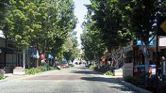
Sunnyvale ( /ËnsÊuniveɪl/ or /ËnsÊunivÉol/) is a city in Santa Clara County, California, United States. It is one of the major cities that make up the Silicon Valley located in the San Francisco Bay Area. It is the seventh most populous city in the San Francisco Bay Area. As of the 2010 Census, the population was 140,095.
The city is bordered by portions of San Jose to the north, Moffett Federal Airfield to the northwest, Mountain View to the west, Los Altos to the southwest, Cupertino to the south, and Santa Clara to the east. It lies along the historic El Camino Real and Highway 101.
As part of the Silicon Valley, high-tech companies such as Maxim Integrated Products, Juniper Networks, Fortinet, Palm, Inc., AMD, NetApp, Spansion, Yahoo!, AppliedMicro and Ariba are headquartered there. Sunnyvale is also home to several aerospace/defense companies; Lockheed Martin has a major facility in Sunnyvale, and Honeywell, Northrop Grumman Electronic Systems - Marine Systems (formerly Joshua Hendy Iron Works), Finisar, and Spirent also have offices in Sunnyvale. Sunnyvale is also the home to Onizuka Air Force Station, where its main building, locally known as the Blue Cube, is its most prominent feature. The base, named for the deceased Space Shuttle Challenger astronaut Ellison Onizuka, was the primary artificial satellite control facility of the United States armed forces until August 2010.
Sunnyvale is one of the few U.S. cities to have a single unified Department of Public Safety, where all personnel are trained as firefighters, police officers, and EMTs, so they can respond to an emergency in any of the three roles.
Library services for the city are provided by the Sunnyvale Public Library, located at the Sunnyvale Civic Center.
Sunnyvale is located at 37 °22 a²7.56 a³N 122 °2 a²13.4 a³W / 37.3687667 °N 122.037056 °W / 37.3687667; -122.037056.
According to the United States Census Bureau, the city has a total area of 22.7 square miles (58.8 km ²), of which, 22.0 square miles (56.9 km ²) of it is land and 0.7 square miles (1.8 km ²) of it (3.09%) is water. The elevation is 130 feet above sea level.
Like most of the San Francisco Bay Area, Sunnyvale has a Mediterranean climate, with mild, moist winters and comfortably warm, very dry summers. Average daytime summer temperatures are in the high 70s, and during the winter, average daytime high temperatures rarely stay below 50 °F (10 °C). Snowfall is rare, but on January 21, 1962, and February 5, 1976, measurable snowfall occurred in Sunnyvale and most of the San Francisco Bay Area. Sunnyvale was briefly hit by tornados in 1998, but otherwise they are extremely rare.
When the Spanish first arrived in the 1770s at the Santa Clara Valley, it was heavily populated by the Ohlone native Americans. In 1777, Mission Santa Clara was built by Ohlone who converted to Christianity.
In 1842, Rancho Pastoria de las Borregas was granted to Francisco Estrada and his wife Inez Castro. Portions of the land given in this grant later developed into the cities of Mountain View and Sunnyvale. Two years later, in 1844, another land grant was provided to Lupe YR±igo, one of the few Native Americans to hold land grants. His land grant was first called Rancho Posolmi, named in honor of Posolmi village of the Ohlone that once stood in the area. Rancho Posolmi was later known as Rancho Ynigo.
Martin Murphy Jr. came to California with his father as part of the Stephens-Townsend-Murphy Party in 1844. In 1850, Martin Murphy Jr. bought a piece of Rancho Pastoria de las Borregas for $12,500. Murphy established a wheat farm and ranch named Bay View. Murphy had the first wood frame house, which was shipped from New England, in Santa Clara County built. The house was demolished in 1961 but was reconstructed in 2008 as the Sunnyvale Heritage Park Museum. When he died in 1884, his land was divided among his heirs.
In 1860, The San Francisco and San Jose Rail Road was allowed to lay tracks on Bay View and established Murphy Station. Lawrence Station was later established on the southern edge of Bay View.
In the 1870s, county property tax laws, imports and soil degradation caused wheat farming to become uneconomical in Santa Clara County. Small fruit orchards replaced the large wheat farms. In 1871, James and Eloise Dawson established the first fruit cannery in Santa Clara County. Fruit agriculture and canning soon became a major industry in the county. The invention of the refrigerated rail car further increased the viability of an economy based upon fruit. The fruit orchards become so prevalent that in 1886, the San Jose Board of Trade called Santa Clara County the "Garden of the World".
In the 1880s, Chinese workers made up 48 percent of the farm labor in Santa Clara County. This percentage reduced over time after the Chinese Exclusion Act was passed. In the following decade, the 1890s, multitudes of immigrants from Italy, the Azores, Portugal, and Japan arrived to work in the orchards.
In 1897, Walter Everett Crossman bought 200 acres (809,000 m ²) and began selling real estate. He advertised the area as Beautiful Murphy. Later, in the 1900s, real estate developer Walter Crossman described it as "the City of Destiny". Also in 1897, Encina School opened as the first school in Murphy. Previously, children in the town had to travel to Mountain View for school.
In 1901, the residents of Murphy were informed they could not use the names Encinal or Murphy for their post office. They decided to use the name Sunnyvale for the name of their town.
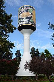
Sunnyvale continued to grow and in 1904, dried fruit production began. Two years later, Libby, McNeill & Libby, a Chicago meat-packing company, decided to open its first fruit packing factory in Sunnyvale. Today, a water tower painted to resemble the first Libby's fruit cocktail can label identifies the former site of the factory.
Also in 1906, the Joshua Hendy Iron Works relocated from San Francisco to Sunnyvale after the company's building was destroyed by fire after the 1906 earthquake. The ironworks was the first non-agricultural industry in the town. The Joshua Hendy Iron Works switched from producing mining equipment to other products such as marine steam engines.
In 1912, the residents of Sunnyvale voted to incorporate, and Sunnyvale became an official city.
Fremont High School first opened in 1923. It served as a military base before the school opened and through World War II. Planes flying to and from Moffett Field, which opened in 1933, commonly stopped here for fuel top-offs. A 1948 yearbook shows a military aircraft parked at one of the buildings as students watch nearby. Fremont High School has old military buildings on its campus including a Quonset hut installed after WWII, now used as a wrestling team facility.
In 1930, Congress decided to place the West Coast dirigible base in Sunnyvale. This naval airfield was later renamed Moffett Naval Air Station and then Moffett Federal Airfield and is commonly called Moffett Field.
In 1939, the National Advisory Committee for Aeronautics (NACA, the forerunner of NASA) began research at Ames Laboratory.
During World War II, the war economy began a change from the fruit industry to the high-tech industry in Santa Clara County. The Joshua Hendy Iron Works built marine steam engines, naval guns and rocket launchers to aid in the war effort. As the defense industry grew, a shortage of workers in the farm industry was created. Immigrants from Mexico came to Sunnyvale to fill this void of workers.
Following the war, the fruit orchards and sweetcorn farms were cleared to build homes, factories and offices. In 1956, the aircraft manufacturer Lockheed moved its headquarters to Sunnyvale. Since then, numerous high-tech companies have established offices and headquarters in Sunnyvale, including Advanced Micro Devices and Yahoo. The first prototype of Pong, one of the first arcade videogames, was installed in Sunnyvale in September 1972, in a bar named Andy Capp's Tavern, now Rooster T. Feathers. In 1970, the Census Bureau reported Sunnyvale's population as 94.6% white and 3.7% Asian.
By 2002, the few remaining orchards were demolished and replaced with homes and shops. However, there are still city-owned orchards, such as the Heritage Orchard next to the Sunnyvale Community Center.
In 1979, an indoor mall called Sunnyvale Town Center opened in what used to be a traditional downtown shopping district. After years of successful operation, the mall started to decline in the 1990s. After numerous changes in plans and ownership, the mall was demolished in 2007, and a new downtown shopping district is being constructed in its place.
Sunnyvale celebrated its one-hundredth anniversary, on August 25th, 2012.
The 2010 United States Census reported that Sunnyvale had a population of 140,081. The population density was 6,173.9 people per square mile (2,383.8/km ²). The racial makeup of Sunnyvale was 60,193 (43.0%) White, 2,735 (2.0%) African American, 662 (0.5%) Native American, 57,320 (40.9%) Asian, 638 (0.5%) Pacific Islander, 12,177 (8.7%) from other races, and 6,356 (4.5%) from two or more races. Hispanic or Latino of any race were 26,517 persons (18.9%). Non-Hispanic Whites were 34.5% of the population in 2010, compared to 74.7% in 1980.
The Census reported that 139,232 people (99.4% of the population) lived in households, 380 (0.3%) lived in non-institutionalized group quarters, and 469 (0.3%) were institutionalized.
There were 53,384 households, out of which 18,614 (34.9%) had children under the age of 18 living in them, 28,583 (53.5%) were opposite-sex married couples living together, 4,629 (8.7%) had a female householder with no husband present, 2,341 (4.4%) had a male householder with no wife present. There were 2,386 (4.5%) unmarried opposite-sex partnerships, and 357 (0.7%) same-sex married couples or partnerships. 13,457 households (25.2%) were made up of individuals and 3,775 (7.1%) had someone living alone who was 65 years of age or older. The average household size was 2.61. There were 35,553 families (66.6% of all households); the average family size was 3.15.
The population was spread out with 31,435 people (22.4%) under the age of 18, 9,350 people (6.7%) aged 18 to 24, 50,919 people (36.3%) aged 25 to 44, 32,721 people (23.4%) aged 45 to 64, and 15,656 people (11.2%) who were 65 years of age or older. The median age was 35.6 years. For every 100 females there were 101.5 males. For every 100 females age 18 and over, there were 100.9 males.
There were 55,791 housing units at an average density of 2,458.9 per square mile (949.4/km ²), of which 25,623 (48.0%) were owner-occupied, and 27,761 (52.0%) were occupied by renters. The homeowner vacancy rate was 1.1%; the rental vacancy rate was 4.4%. 68,895 people (49.2% of the population) lived in owner-occupied housing units and 70,337 people (50.2%) lived in rental housing units.
As of the census of 2000, there were 131,760 people, 52,539 households, and 32,679 families residing in the city. The population density was 6,006.5 people per square mile (2,318.7/km ²). There are 53,753 housing units at an average density of 946.0 persons/km ² (2,450.4 persons/sq mi). The racial makeup of the city is 53.27% White, 32.27% Asian, 2.22% African American, 0.46% Native American, 0.32% Pacific Islander, 7.19% from other races, and 4.25% from two or more races. 15.48% of the population are Hispanic or Latino of any race.
There were 52,539 households out of which 27.6% had children under the age of 18 living with them, 50.0% were married couples living together, 8.2% had a female householder with no husband present, and 37.8% were non-families. 27.1% of all households were made up of individuals and 6.4% had someone living alone who was 65 years of age or older. The average household size was 2.49 and the average family size was 3.06.
In the city the population was spread out with 20.4% under the age of 18, 7.7% from 18 to 24, 41.3% from 25 to 44, 19.9% from 45 to 64, and 10.6% who were 65 years of age or older. The median age was 34 years. For every 100 females there were 105.9 males. For every 100 females age 18 and over, there were 106.5 males.
Under the 2000 Census, the median income for a household in the city was $74,409, and the median income for a family was $81,634, but under the Census Bureau's 2008 estimates, these figures have risen to $88,297 and $105,492, respectively.
Under the 2000 Census, males had a median income of $65,165 versus $43,051 for females. The per capita income for the city was $36,524. About 3.7% of families and 5.4% of the population were below the poverty line, including 5.5% of those under age 18 and 5.2% of those age 65 or over.
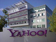
8x8, Advanced Micro Devices, Applied Micro, Applied Signal Technology, Ariba, Aruba Networks, Blue Coat Systems, Dionex, Finisar, Fortinet, Infinera, Intuitive Surgical, Juniper Networks, Maxim Integrated Products, MIPS Technologies, NetApp, PLX Technology, Rambus, ShoreTel, Silicon Image, Spansion, TeleNav, Trimble Navigation, Yahoo!, and Zoran are among the companies based in Sunnyvale.
According to the City's 2011 Comprehensive Annual Financial Report, the top employers in the city are:
In the state legislature Sunnyvale is located in the 13th Senate District, represented by Democrat Elaine Alquist, and in the 22nd Assembly District, represented by Democrat Paul Fong. Federally, Sunnyvale is located in California's 14th congressional district, which has a Cook PVI of D +21 and is represented by Democrat Anna Eshoo. As of March 20, 2009, Sunnyvale had 56,466 registered voters: 25,677 were Democrats, 12,716 Republicans, with the remaining 18,073 not belonging to either major party. The mayor and vice-mayor of Sunnyvale are not directly elected. Instead they are selected from the city council members by the city council, serving two-year and one-year terms, respectively.
Sunnyvale has several neighborhoods, and while they are not "official" enough to be named on a map, they are the principal designations that are used by the many neighborhood associations recognized by the city. These neighborhoods include
The City of Sunnyvale maintains a neighborhood association registry.
The southern half of Sunnyvale is predominantly residential, while most of the portion of Sunnyvale north of Highway 237 is zoned for industrial use.
The far eastern section of El Camino Real in Sunnyvale has a significant concentration of businesses owned by South Indian immigrants.
The area of the city bounded by Fremont Avenue and Cupertino to the south, and Los Altos to the west, is considered to be more desirable to reside as measured by home values.
There are many parks in the Sunnyvale Area. These include Las Palmas Park, Ortega Park, Washington Park near downtown, two public golf courses, and Baylands Park, site of the annual Linux Picnic. Full Circle Farm , encompassing 11 acres, is the largest community-based urban farm in Silicon Valley, and is located in the Birdland neighborhood of Sunnyvale. Charles Street Gardens , Sunnyale's oldest and largest community garden, is located adjacent to Sunnyvale's Public Library.
In November 2009, previously closed portions of the main streets in downtown Sunnyvale were reopened as part of the ongoing downtown redevelopment, marking the first time in over three decades that those street blocks have been open to vehicle and pedestrian traffic. In December 2009, work was started to finish the exteriors of the residential buildings on McKinley Ave and Washington Ave, the two office towers on Mathilda and weatherize the remaining partially completed Redwood Square buildings until the project's resolution can be determined.
In May 2010, Nokia signed a lease to occupy the first office tower at the intersection of Washington Avenue and Mathilda Avenue and to make Sunnyvale its North America headquarters. This is seen as a huge step forward in the marketability of the project to a potential buyer.
In February 2012 Apple announced that it had leased the second office tower, with the intention of occupying the building by the third quarter of 2012.
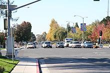
Sunnyvale is served by the Santa Clara Valley Transportation Authority (both light rail and buses) and the Caltrain commuter rail. The SR 85, US 101, SR 237, and I-280 freeways run through the city. A segment of State Route 82 runs through the center of the city, following the path of historic El Camino Real. Sunnyvale has also been listed by the League of American Bicyclists as a Bicycle Friendly Community at the bronze level, having multiple on-street and off-street bike lanes, bicycle-activated traffic signals, and bicycle accommodations on both VTA and Caltrain. The Bicycle and Pedestrian Advisory Committee advises the city council on the continued development of the bicycle plan for the city.
For commercial passenger air travel, Sunnyvale is well served by three nearby international airports. The closest, Norman Y. Mineta San Jose International Airport (SJC) is a 9.5-mile drive from downtown Sunnyvale by car. It is also accessible by Caltrain, VTA light rail and VTA bus (with both the Caltrain and Light Rail stations requiring transfer to a free shuttle bus to get to the airport terminal). The next closest is San Francisco International Airport (SFO), which is 27.7 miles by car. SFO is also transit accessible via Caltrain and Bay Area Rapid Transit (BART). The Metropolitan Oakland International Airport (OAK), which is 37.5 miles by car. Access to Oakland airport by public transit is possible via multiple transfers.
Sunnyvale has consistently ranked as one of the safest ten cities (for cities of similar size) in the United States according to the FBI's crime reports. From 1966 to at least 2004, Sunnyvale never placed below fifth in safety rankings among U.S. cities in its population class. In 2005, Sunnyvale ranked as the 18th-safest city overall in the U.S., according to the Morgan Quitno Awards. In 2009, Sunnyvale was ranked 7th in U.S. by Forbes Magazine in an analysis of America's safest cities.
A long standing legend of Sunnyvale is of a ghost that haunts the town's Toys 'R' Us store. A purported psychic, Sylvia Browne, claimed to have made contact with the ghost on the 1978 TV show "That's Incredible" and named him Johnny Johnson. This story was also explored in a 1991 episode of "Haunted Lives: True Ghost Stories". Furthermore, she stated that he had been a farm hand who worked in the orchard where the toy store now stands and that he bled to death from an accidental, self-inflicted axe injury to his leg.

Word Count: 3866


